Geologists often mention the existence long ago of Pangea, a supercontinent from which today's Earth landmasses evolved. I agree that there was indeed a 'supercontinent' - the geologic evidence sourced from around the world comprehensively says so.
However, I contend that Pangea was not a supercontinent surrounded by water. The evidence I have uncovered actually goes a step further and strongly suggests that Pangea was not merely an island - Pangea was actually the surface of a (smaller) Earth in its entirety, covered by oceans upon which sat numerous islands and continents.
I believe that the reader should take a little time to review the implications of this and then place a 'whole world Pangea' within the context of an Impact And Exit Event.
I also believe that the evidence I present within the hypothesis will prove to be compelling, so compelling that perhaps perceptions will begin to change over time.
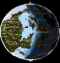
Earth (Pangea) pre-Impact And Exit Event would probably have looked something like the following image. Note the perpendicular axis on which Earth rotates. In terms of axial rotation this would be a perfectly natural way for a planet such as ours to perform if it had not been involved in an impact of this scale (that is to say perpendicular to the plane of the ecliptic):
The Impact and Exit Event hypothesis also explains in great detail how, and why our Moon orbits around Earth at such a strange angle compared to a) the plane of the ecliptic and b) Earth's equator. You will be amazed at the natural simplicity of it all!
Let us return to the exit event:
As Earth expanded following the impact the oceans simply drained into the emerging void created by the (eventual) Atlantic and Pacific oceans. Again, there is ample evidence to support this within the book ...and elsewhere.
The following images reveal the site of the exit event. The existing continental landscape clearly indicates the direction in which unimaginable amounts of debris was hurtled outwards as the impactor once again approached the surface of Earth from underneath (e.g. in a westerly and southwesterly direction), initially peppering the surface before bursting out at the main exit site.
The main exit 'wound' can clearly be seen as an oval depression on the surface of Earth at the centre of each image (try searching the Internet for images of the 'Takla Makan Desert' - because this is it):
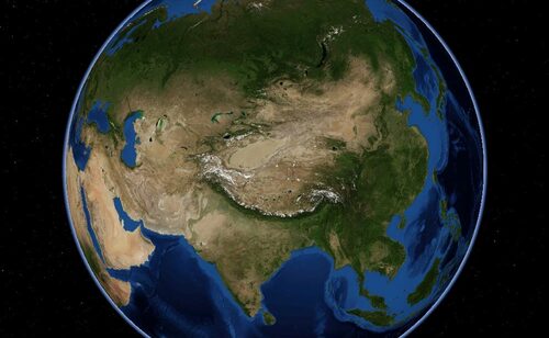
Image courtesy of NASA
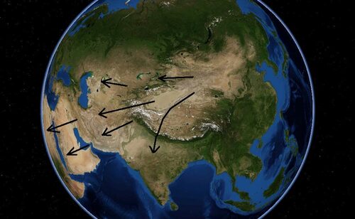
Image courtesy of NASA
There are a lot of examples similar to these within the 220+ pages of The Impact And Exit Event. If you are interested and would like to find out more details about this unique hypothesis click here to instantly download your copy.